


Precision GPS Free
คำอธิบายของPrecision GPS Free
'Precision GPS Free' uses your device's GPS sensor to measure your location more accurately than is possible with typical GPS apps. Turn your phone or tablet into a precision GPS instrument.
Normally, software on your Android device determines your location from individual GPS readings. This is fine if your are interested in getting your location to within about 10 meters. However, it is possible to do better than this if you average many readings at a particular location.
This app is designed to do just that -- average many readings of a stationary Android device to get a more accurate location; it actually calculates a weighted average, accounting for the accuracy of each reading. The trade-off is time. You will need to wait a least a few minutes to get a high accuracy average location.
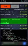
'Precision GPS Free' displays the following information on the main screen:
-'start/stop' button,
-'reset' button,
-battery power remaining as percentage,
-current latitude and longitude,
-round number,
-elapsed time,
-number of GPS satellites in view,
-number of GPS satellites employed in fixing location,
-signal-to-noise ratio of signal from each satellite,
-accuracy of the current readings,
-weighted average (mean) latitude and longitude,
-graph of the current latitude and longitude (white connected points) and the average value (red dot),
-bounding 'scale box' (green) around mean position with a width and a height of 2 meters.
The reset button is inactive while readings are being taken. It can be used after the 'stop' button is pressed. If the measurements are stopped and then started again without pressing the reset button, then only the 'elapsed time' value is reset.
The latitude and longitude values are shown on the graph. North is towards the top and east is toward the right, as in a map. The graph automatically rescales to include the extreme values of longitude and latitude each time it updates the graph (every four seconds). The green scale box is not always square in shape, since the graph latitude scale is not necessarily the same as the graph scale in longitude.
The app times out after 30 seconds if the device cannot get a satellite fix.
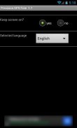
A 'settings' screen provides an option to keep the screen continuously on while the app is running.
Localization language support is provided for French, German, and Spanish.
This app does not save or transmit any personal information, including location or pictures. All the required permissions relate to the GPS operation and the ads.
Applications of 'Precision GPS Free' include navigation, geocaching, prospecting, emergencies, surveying a property, observational astronomy, and archaeology.
A pro version of this app is also available, called 'Precision GPS Pro'. It adds elevation and HDOP, PDOP, VDOP data and options to save the location (and copy to the clipboard), change the interval that readings are taken, display UTM coordinates, display a sky map of the active satellite positions, run in the background, change the format of the coordinates, and send the average coordinates to a mapping app, such as 'Google Maps.' The pro version is also ad-free.
If you have any suggestions for improvements or problem reports, please contact us at ggonzo47@gmail.com.
'พรีซิชั่จีพีเอสฟรี' ใช้เซ็นเซอร์จีพีเอสของอุปกรณ์ในการวัดตำแหน่งของคุณถูกต้องมากขึ้นกว่าที่เป็นไปได้ด้วยแอพพลิเคจีพีเอสทั่วไป เปิดโทรศัพท์หรือแท็บเล็ตของคุณให้เป็นเครื่องมือจีพีเอสที่มีความแม่นยำ
ปกติซอฟต์แวร์บนอุปกรณ์ Android ของคุณจะเป็นตัวกำหนดตำแหน่งของคุณจากการอ่านจีพีเอสของแต่ละบุคคล นี่คือดีถ้าคุณมีความสนใจในการรับตำแหน่งของคุณไปภายในเวลาประมาณ 10 เมตร แต่ก็เป็นไปได้ที่จะทำได้ดีกว่านี้ถ้าคุณเฉลี่ยการอ่านจำนวนมากในสถานที่เฉพาะ
app นี้ถูกออกแบบมาเพื่อทำแค่นั้น - อ่านจำนวนมากเฉลี่ยของอุปกรณ์ Android นิ่งที่จะได้รับตำแหน่งที่ถูกต้องมากขึ้น มันจริงคำนวณค่าเฉลี่ยถ่วงน้ำหนัก, การบัญชีสำหรับความถูกต้องของการอ่านแต่ละ การปิดเป็นเวลา คุณจะต้องรออย่างน้อยไม่กี่นาทีเพื่อให้ได้ความแม่นยำสูงเฉลี่ยที่ตั้ง
'พรีซิชั่จีพีเอสฟรี' แสดงข้อมูลต่อไปนี้บนหน้าจอหลัก:
-'start / หยุด 'ปุ่ม
-'reset 'ปุ่ม
พลังงานแบตเตอรี่ที่เหลือเป็นร้อยละ
เส้นรุ้งและเส้นแวงที่หมุนเวียน,
จำนวนกลม,
เวลา -elapsed,
จำนวนของดาวเทียม GPS ในมุมมองของ
จำนวนของดาวเทียม GPS ที่ใช้ในการแก้ไขสถานที่
อัตราส่วน -signal ต่อเสียงรบกวนของสัญญาณจากแต่ละดาวเทียม
-accuracy ของการอ่านในปัจจุบัน
ถัวเฉลี่ยถ่วงน้ำหนัก (เฉลี่ย) เส้นรุ้งและเส้นแวง
-graph ของเส้นรุ้งและเส้นแวงที่ปัจจุบัน (จุดเชื่อมต่อสีขาว) และค่าเฉลี่ย (จุดสีแดง)
-bounding กล่องขนาด '(สีเขียว) รอบตำแหน่งเฉลี่ยที่มีความกว้างและความสูง 2 เมตร
ปุ่มรีเซ็ตไม่ได้ใช้งานในขณะที่การอ่านที่ถูกนำ มันสามารถนำมาใช้หลังจากที่ปุ่ม 'หยุด' ถูกกด ถ้าวัดที่จะหยุดการทำงานแล้วเริ่มต้นอีกครั้งโดยไม่ต้องกดปุ่มรีเซ็ตแล้วเท่านั้น 'เวลาที่ผ่านไปค่าจะถูกรีเซ็ต
ละติจูดและลองจิจูดค่าจะแสดงบนกราฟ ทิศตะวันตกเฉียงเหนือไปทางด้านบนและด้านทิศตะวันออกไปทางด้านขวาเช่นเดียวกับในแผนที่ กราฟอัตโนมัติ rescales ที่จะรวมค่าสุดของลองจิจูดและละติจูดทุกครั้งที่มีการปรับปรุงกราฟ (ทุกสี่วินาที) ขนาดกล่องสีเขียวจะไม่เสมอตารางในรูปทรงขนาดตั้งแต่ละติจูดกราฟไม่จำเป็นต้องเป็นเช่นเดียวกับระดับในกราฟเส้นแวง
ครั้งการตรวจสอบออกมาหลังจาก 30 วินาทีถ้าอุปกรณ์ไม่สามารถได้รับการแก้ไขดาวเทียม
หน้าจอการตั้งค่า 'มีตัวเลือกที่จะทำให้หน้าจออย่างต่อเนื่องในขณะที่ app ทำงาน
สนับสนุนภาษาหลายภาษาที่มีให้สำหรับฝรั่งเศส, เยอรมันและสเปน
app นี้ไม่ได้บันทึกหรือส่งข้อมูลส่วนบุคคลใด ๆ รวมถึงสถานที่หรือภาพ ทุกสิทธิ์ที่จำเป็นที่เกี่ยวข้องกับการดำเนินงานจีพีเอสและโฆษณา
การประยุกต์ใช้งานของพรีซิชั่จีพีเอสฟรีรวมถึงการนำทางของ geocaching แร่ฉุกเฉินการสำรวจสถานที่ให้บริการดาราศาสตร์และโบราณคดี
รุ่นโปรของ app นี้นอกจากนี้ยังมีที่เรียกว่าพรีซิชั่จีพีเอสโปร ' มันจะเพิ่มระดับความสูงและ HDOP, PDOP ข้อมูล VDOP และตัวเลือกที่จะบันทึกสถานที่ (และคัดลอกไปยังคลิปบอร์ด) เปลี่ยนช่วงเวลาที่จะได้รับการอ่าน, การแสดงพิกัด UTM แสดงแผนที่ท้องฟ้าตำแหน่งดาวเทียมที่ใช้งานอยู่ทำงานในพื้นหลัง เปลี่ยนรูปแบบของพิกัดและส่งพิกัดเฉลี่ยในการตรวจสอบการทำแผนที่เช่น 'Google Maps. รุ่นโปรยังเป็นโฆษณาฟรี
หากคุณมีข้อเสนอแนะสำหรับการปรับปรุงหรือรายงานปัญหาโปรดติดต่อเราได้ที่ ggonzo47@gmail.com
Precision GPS Free--เวอร์ชั่น2.1
(17-12-2018)Precision GPS Free - ข้อมูล APK
เวอร์ชั่น APK: 2.1แพ็คเกจ: com.sciencewithandroid.precisiongpsfreeเวอร์ชั่นล่าสุดของPrecision GPS Free


แอปในประเภทเดียวกัน

คุณอาจจะชอบ...


